Physical geography - Climatology
Lecture in WS 2021/22 Climatology (BBGW5.1.5; Friedolin: 46988)
Lecturers: Christoph Gerbig, Sönke Zaehle
Location: online, via zoom, link via email
Time: Monday 2:15 p.m. - 4:00 p.m.
First lecture: Monday, October 18, 2021
| Datum | Thema | Dozent | Folien |
| 2021 | |||
| 18.10.2021 | Introduction, climate history | Gerbig | X |
| 25.10.2021 | Energy balance | Gerbig | X |
| 01.11.2021 | Processes in the climate system: ocean / atmosphere | Gerbig | X |
| 08.11.2021 | Processes in the climate system: land surfaces / cryosphere | Gerbig | X |
| 15.11.2021 | Climatic zones & climate classification | Zaehle | X |
| 22.11.2021 | Measuring systems for climate observation I | Gerbig | X |
| 29.11.2021 | Measurement systems for climate observation II | Gerbig | X |
| 06.12.2021 | Modeling the climate system: from weather forecast to climate model | Zaehle | X |
| 13.12.2021 | Natural climate variability | Zaehle | X |
| 2022 | |||
| 03.01.2022 | Simulations of climate change | Zaehle | |
| 10.01.2022 | Greenhouse gas cycles I: Global carbon cycle | Zaehle | |
| 17.02.2022 | Greenhouse gases II: interaction of biogeochemistry and climate system | Zaehle | |
| 24.01.2022 | Climate and Society | Zaehle | |
| 10.02.2022 | Written exam (online !!) | Zaehle/Gerbig |
Background and aim of the lecture
The lecture climatology aims to provide an overview of the global climate system. Climate-relevant processes in the various components of the climate system (atmosphere, ocean, land surfaces and cryosphere) and their interactions are dealt with.
By climate we understand the state of our environment, characterized by temperature, humidity, precipitation, etc., averaged over a sufficiently long period, e.g. 30 years, to eliminate short-term fluctuations, the weather.
The earth's climate is subject to fluctuations over time, which are caused by changes in external influences (e.g. changes in global radiation due to changing cosmic conditions), but also by internal changes in the interaction between the various components of the climate system. The change of the seasons or the ice age cycles are caused by changes in solar radiation. Other climatic fluctuations such as the "El Niño-Southern Oscillation" phenomenon or the drought in the Sahel are caused by internal shifts in the atmosphere-ocean-land-surface system.
The different spatial radiation of solar energy between the equator and poles, the ocean currents and the great contrast in the properties of land and sea lead to the formation of different climatic zones which characterize the regional climate. On smaller spatial and temporal scales, the atmospheric circulation and the weather systems determine the local climate.
While today's climate can be observed through direct as well as satellite-based measurements, so-called proxy data, e.g. from ice core examinations or the examination of tree rings, provide information about historical climate changes.
In addition to natural climate fluctuations, humans today influence the climate through emissions of greenhouse gases from the combustion of fossil fuels, but also through changes in land use (e.g. clearing of forests). In order to estimate the potential effects on the global climate system, great efforts are currently being made to decipher the various interaction chains and to represent them in numerical simulation models of the earth system. With the help of these models, projections of "global change" can then be created based on scenarios of future population and economic development on earth.
The following subject areas are dealt with in the lecture:
1. Climate variability: overview of recent climate history.
2. Energy balance, feedback effects
3. Components of the climate system and their dynamics based on the physical-chemical-biological basic equations:
- The atmosphere
- ocean
- cryosphere
- Land surfaces and hydrological cycle
4. Observations: from local temperature measurements to remote sensing using satellites
5. Climate classification: climate zones, regional climate, local climate
6. Representation of the climate system in numerical simulation models
7. Natural climate variability: ENSO, sunspots, Milankovitch cycles
8. Global change:
- Anthropogenic driving factors
- Simulations of global change
- Detection of the anthropogenic influence
To deepen the lecture material, simple process models of individual system components are developed in order to research the various interaction chains. All materials will be made available for download on the internet during the course of the lecture.
Elementary knowledge of physics, chemistry and mathematics is required for participation.
Literature
M. Kappas: "Klimatologie", Spektrum Akademischer Verlag, Heidelberg, 2009 (ISBN 978-3-8274-1827-2)
J. M. Wallace and P. V. Hobbs: "Atmospheric Science", Academic Press, San Diego, 2002 (ISBN 0-12-732950-1)
J. R. Holton (Editor): "Encyclopedia of atmospheric sciences" Academic Press, Amsterdam, 2003 (ISBN: 0-12-227090-8)
L.D. Danny Harvey: "Global Warming, the Hard Science". Pearson Education Limited, Harlow, UK, 2000 (ISBN 0582-38167-3).
D. Archer: “Global Warming, Understanding the Forecast”, Blackwell, (ISBN 978-1-4051-4039-3)
An overview of the global climate system that is also understandable for non-natural scientists can be found in (german): Storch, H.v., S. Guess, and M. Heimann: "Modellierung des Klimasystems: Eine Einführung in Funktionsweise, Anwendungen und Grenzen von konzeptionellen und realitätsnahen Modellen". Springer, Heidelberg, 1999.
A (much more extensive) summary of all facts about global climate change can be found in "Fifth Assessment Report" des Intergovernmental Panel on Climate Change, WG I (ca. 1600 pages):
T. Stocker et al. (Eds.): "Climate Change 2013: The Physical Science Basis". Cambridge University Press, Cambridge, 2013. (ISBN 978-1-107-05799-1). This report is available online on the Websites of Working Group I of the IPCC.
A summary (115 pages) can be found in "Technical Summary of WG I Report". There is still that for decision-makers and non-specialists "Summary for Policymakers" (29 pages). The latter was approved sentence-by-sentence by the delegates of the nations represented in the IPCC.
Supporting material
Webseite with the current satellite images from EUMETSAT. These high-resolution images are recorded by a geostationary satellite (Meteosat 0 degree) over the equator at 0°E and updated every hour. The colors are created by combining three spectral channels in visible light with slightly different wavelength ranges to form an RGB image.
Energy balance models
CDF Modules
CDF format: Requires the free CDF player from Wolfram
Simple energy balance models (zip file): eb1.cdf with an atmosphere layer and constant albedo, eb2.cdf with temperature-dependent albedo, and eb3.cdf with temperature-dependent albedo and additional noise
Older Java and C versions
Webversion of the time-dependent EBM (Courtesy of Sebastian Heimann; requires Java-enabled browser)
c-Version of the time-dependent EBM (from v. Storch, Guess, Heimann)
More material on the energy balance
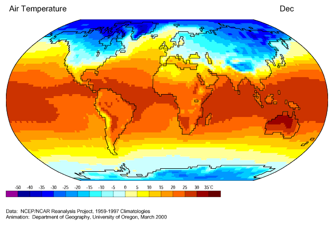
Animations (climatological annual cycle based on the reanalyses of the American weather service NCEP, provided by Department of Geography der University of Oregon).
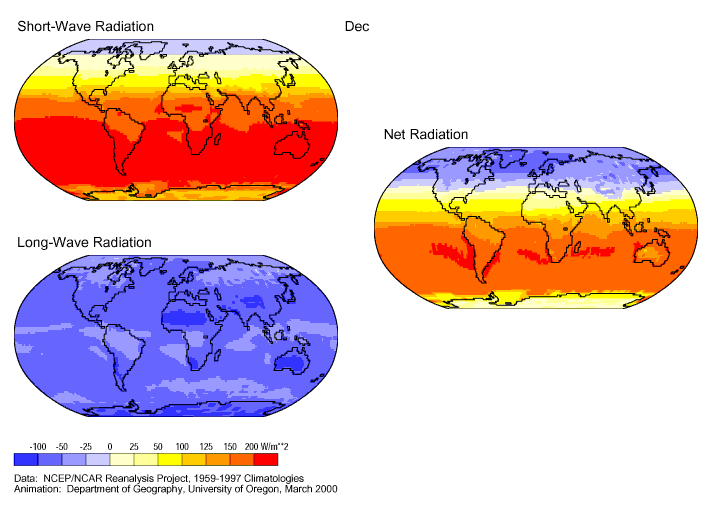
- Components of the Strahlungsbilanzan at the earth's surface
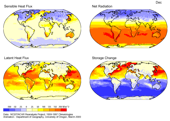
- Energy balance (sensible and latent heat flow, net radiation and storage term) on the earth's surface
Please note:
- the fillable heat flow is positive, i.e. directed upwards when the surface is warmer than the atmosphere above,
- the latent heat flow is always positive, i.e. an energy loss from the earth's surface, except when hoarfrost is formed on the earth in winter
- negative values for the storage term indicate an energy consumption by the earth's surface. The storage term is generally negative in the summer hemisphere and negative in the winter hemisphere. Note that the equatorial ocean in the Pacific always represents an energy sink: here, cool water flows up from deeper layers and is heated on the surface.
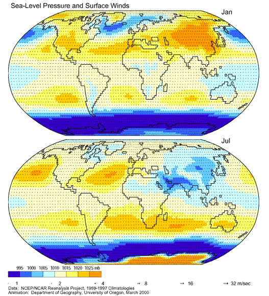
Note that North America and Eurasia are climatologically under the influence of high pressure (falling air) and in summer represent a low pressure area with rising air masses on average. Correspondingly, the circulation is directed away from the continent in winter and towards the continent in summer (monsoon circulation).
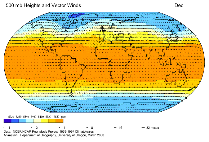
- 500 hPa wind
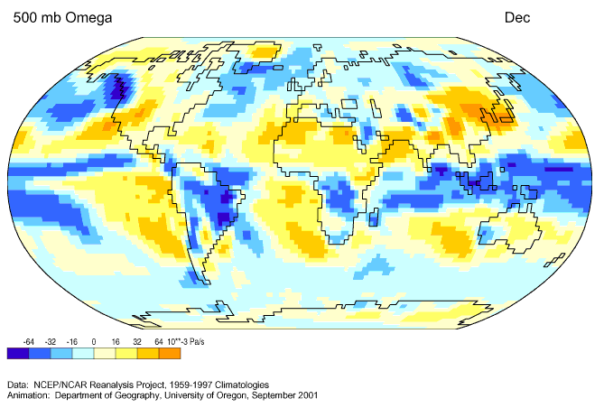
- Vertical wind at 500hPa (shown is Omega = dP / dt - negative values indicate rising air masses). Note the equatorial areas with rising air masses = intertropical convergence zone.
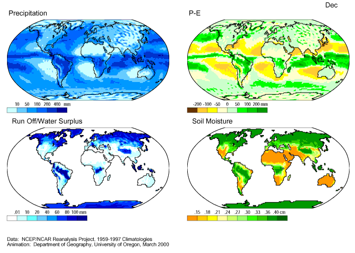
- Components of the water cycle: Precipitation: Precipitation, P-E: Precipitation - evaporation, Runoff: Water that is not absorbed by the soil and transported away by water runoff, Soil moisture: water stored in the ground (top meter).
Further material on processes in the climate system, atmosphere
Animation of the cloud movements over Europe from January 10, 2005 to October 8, 2005, seen by the geostationary satellite (METEOSAT) in the infrared spectral range (note the daily change in the temperature of the earth's surface in the Sahara - dark colors = warm). (Caution: file size 40MB!)
global animation of cloud movements as well as temperatures of land surfaces and oceans, seen by various geostationary satellites in the infrared spectral range.
global animation of the cloud movements seen by various geostationary satellites in the infrared spectral range.
global animation of atmospheric water vapor, seen by various geostationary satellites in the infrared spectral range (other wavelength ranges than clouds).
About Daisyworld
Daisyworld: Java version of a game program for "exploring" Daisyworld (Courtesy of Ginger Booth, Yale University)