Teno River

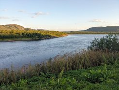
The Teno River (Norwegian: Tana, Northern Sámi: Deatnu) is located at the northern border between Finland and Norway and flows along the community of Utsjoki (69°54'38.7"N 27°01'51.6"E). This river, which is still to the largest part unaffected by dams, used to be one of the largest salmon rivers in Europe and thus famous among fishermen. The river discharges into the Arctic Ocean at the river delta Tanafjorden. Teno River is about 361 km long with a current flow velocity typically varying between 0.5-1 m/s. The study area is located within the isolated permafrost zone and remains relatively undisturbed by human activities (no damming, little agriculture).
In August 2023, IPAS conducted a one-time campaign for two weeks along the river. We collected chamber-based carbon flux and hydrochemical measurements which were complemented by an assessment of hydrophysical river characteristics by colleagues from the University of Helsinki. This campaign was mainly embedded in the GreenFeedBack project.
Preliminary results from chamber measurements suggest generally low carbon fluxes from the water surface of the river system to the atmosphere not exceeding emissions of 2 µmol m-2 s-1 CO2, and 15 nmol m-2 s-1 of methane.

@IPAS Group

@Ivan Mammarella

@Ivan Mammarella

@IPAS Group

@IPAS Group

@IPAS Group

@IPAS Group

@IPAS Group

@IPAS Group