Interaction between Arctic landscapes and the atmospheric boundary layer
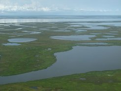
Arctic landscapes are often characterized by vastly variable spatial heterogeneity. For example, when permafrost thaws, typical heterogeneous patterns of alternating lakes and grasslands emerge.

Both types of land covers affect the lowest layer of the atmosphere, the boundary layer, very differently. Lakes and grasslands reflect incoming solar radiation differently causing varying heat fluxes from the surface into the air driving turbulence and larger scale air circulations. Water and grass have different roughness (or friction) which drags the wind at the surface and generates, therefore, different vertical wind profiles.
In order to study the interaction between the atmosphere and the landscape, we need a measure for the spatial heterogeneity. This may be achieved by introducing a typical length scale, i.e. the mean distance between lakes. The smaller the typical length scale, the more heterogeneous the landscape and vice versa.

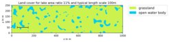
To study the significance of the typical length scale for the boundary layer circulation in a systematic fashion, we performed computer simulations (large eddy simulations) of the atmosphere where we generated many random Arctic landscapes consisting purely of lakes and grasslands with predefined typical length scales, heat fluxes and roughness.
A display of the results of such a simulation can be found in below video.

When analyzing the results we focus, in particular, on the turbulent vertical heat flux. As surface heterogeneity affects the characteristics of the atmospheric turbulence and since the surface temperature is very sensitive to the vertical turbulent heat flux, potential feedback mechanisms for, say, permafrost thaw may arise.

Snapshot of vertical wind velocity over a stochastic tundra landscape presenting fully developed stationary turbulence due to wind shear and convection.
