MoReDEHESHyReS
Modelling Responses of Dehesas with Hyperspectral Remote Sensing
BMBF Förderprogramm „nationales Erdbeobachtungsprogramm“ funded by DLR
Introduction
Biogeochemical modeling relies on remote sensing information to represent mass and energy transfers between the biosphere and the atmosphere. These remote sensing products are so far related to land use, structural and/or biochemical variables of vegetation; some of which are as well Essential Biodiversity Variables (EBV). However, products describing key physiological variables are still missing. Consequently, rough estimates are used at global scale instead, leading to large uncertainties. The estimation of these variables requires can be achieved coupling different models describing radiation transfer and vegetation functioning; however, due to the large number of variables involved overdetermined information is needed for the inversion problem.
MoReDEHESHyReS develop methodologies to exploit hyperspectral information from the Environmental Mapping and Analysis Program (EnMAP) mission in order to generate new products mapping new EBV describing plant physiology and vegetation traits and structure.
Methods
MoReDEHESHyReS methodology will be tested using hyperspectral ground and airborne data acquired in a Mediterranean tree-grass ecosystem located in Majadas del Tiétar, Cáceres, Spain. I this site, a complete set of replicated Eddy covariance ecosystem and subcanopy towers support a large scale fertilization experiment (MANIP). Spectral data were acquired from ground (SMANIE) and airborne (DEHESHyRe, FLUXPEC), SynerTGE) platforms simultaneously to surface fluxes.

MoReDEHESHyReS will start assessing the impact of EnMAP sensor features on the relationships existing between spectral information and fluxes. Then, the retrieval algorithm of physiological EBV will be developed using these high-resolution datasets via radiative transfer and global vegetation models coupling with different degrees of complexity. Model inversion will be supported by Machine Learning techniques. Finally, the model will be tested using synthetic EnMAP imagery developed from the DEHESHyRe airborne datasets.

Main Results
MoReDEHESHyReS has used observations of hyperspectral reflectance factors, chlorophyll sun-induced fluorescence, thermal radiance and gross primary production to develop new methods to retrieve functional traits of vegetation such as maximum carboxylation rate or the slope of the Ball-Berry model. These methods rely on the inversion of radiative transfer models coupled with soil-vegetation-atmosphere models, such as the Soil Canopy Observation, Photochemistry and Energy fluxes: SCOPE (van der Tol et al., 2009).
Close range observations acquired in the context of the SMANIE were used to develop new methods and to evaluate the capability of different observations to adequately constrain the model (Pacheco-Labrador, et al., 2019). Results showed the strong potential of combined hyperspectral reflectance factors, thermal radiance and gross primary production to obtain suitable estimates of functional and biophysical traits. In order to contribute to the development of new remote sensing products, MoReDEHESHyReS has made publicly available the code performing this inversion.
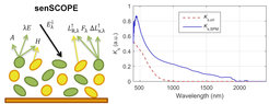
However, thorough evaluation of the results revealed that SCOPE model did not represent accurately the Mediterranean grassland under study. The presence of litter and senescent material biased the estimates of key variables such as chlorophyll content during summer. This led to the development of a new version of SCOPE representing mixed canopies featuring green and senescent leaves: senSCOPE (Pacheco-Labrador, et al., 2021). SenSCOPE separately represents these two different leaves, each performing different optical properties and functions. In fact, in this work we characterized the specific absoprtion coefficients of senesced plant material pigments, which proved a strong influence in the near infrared region. The comparison of SCOPE and senSCOPE using both simulated and observational datasets has shown that the second better represents Mediterranean grasslands, improving the estimation of functional and biophysical parameters of vegetation. MoReDEHESHyReS has made publicly available the code of this new model.
")
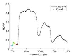
The capability of methods developed using close range observations to provide robust estimates of key functional and biophysical traits from remote sensing has been tested at the same study site using both airborne hyperspectral imagery and synthetic EnMAP imagery produced by the mission End-to-End simulator. Ecosystem scale retrievals were carried out combining this imagery with eddy covariance fluxes from the three towers monitoring the MANIP experiment. The evaluation of the estimates with data of three different footprints under different fertilization regimes prove that despite several sources of uncertainty, MoReDEHESHyReS approach is robust, and capable of producing reliable estimates both from airborne and spaceborne hyperspectral imagery (Pacheco-Labrador, et al., 2020b), such as the one that will be provided by the mission EnMAP (DLR). Additional studies characterizing the effects of spatial and temporal variability on gross primary production modeling in this tree-grass ecosystem were first out previously (Pacheco-Labrador, et al., 2017).
In total, MoReDEHESHyReS has directly produced 4 manuscripts and 5 contributions to international conferences. Moreover, the project has contributed to 8 additional manuscripts and 10 international conferences. Current research activities will bring more contributions in different fields.
Conclusions
MoReDEHESHyReS has developed new approaches to estimate key functional parameters of vegetation (maximum carboxylation rate, Ball-Berry stomatal sensitivity) together with biophysical parameters relevant for water and carbon fluxes modeling (e.g., leaf area index, chlorophyll content). These methods rely on the strong constrain imposed by hyperspectral imagery, and time series of carbon fluxes and thermal radiance. MoReDEHESHyReS has proved that these methods can be applied to spaceborne hyperspectral imagery such as the one that will be provided by the mission EnMAP. During this path, the project has contributed to the remote sensing community with a new model better representing environments featuring mixed green and senescent plants, such as Mediterranean, semi-arid and other grasslands.
MoReDEHESHyReS is a step forward in the development of a new generation of remote sensing products characterizing vegetation function from space.
Publications