Research flights over Canada analyze greenhouse gases
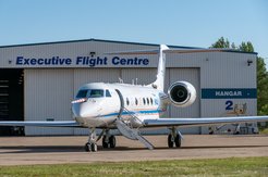
Coal mining, oil and gas extraction, landfills and agriculture - all these are man-made sources of the greenhouse gas methane (CH4), which, after carbon dioxide (CO2), fuels climate change most strongly. In addition, large wetlands and thawing permafrost are important natural sources and sinks in the global CH4 and CO2 budget. To find out more precisely how much greenhouse gases these sources emit in detail and how natural and man-made sources can be better separated in the analysis, the German research aircraft HALO is on mission over Canada in August and September 2022. As part of the CoMet 2.0 Arctic mission (Carbon dioxide and methane mission for HALO), the German Aerospace Center (Deutsches Zentrum für Luft- und Raumfahrt; DLR), together with partners from the Max Planck Institute for Biogeochemistry in Jena, the University of Bremen and Ludwig Maximilian University (LMU) in Munich, is conducting research to record climate gas emissions more accurately and comprehensively in the future and to make climate forecasts more precise.
As part of the mission, new types of instruments are being tested for more precise recording of greenhouse gases. The CHARM-F lidar instrument, newly developed at the DLR Institute of Atmospheric Physics, can use a laser to measure methane and CO2 from a great distance and with high accuracy. "In the future, such a lidar instrument will determine regional and global emissions of the greenhouse gas methane from space as the core of the German-French satellite mission MERLIN," explains project leader Dr. Andreas Fix from the DLR Institute of Atmospheric Physics in Oberpfaffenhofen.

In addition, HALO carries the newly developed MAMAP2DL spectrometer from the University of Bremen, which images methane and carbon dioxide from local sources, as well as the specMACS high-resolution spatial imaging spectrometer from LMU Munich. Complementing the scientific instrumentation are two cavity ringdown spectrometers from the Max Planck Institute for Biogeochemistry (MPI-BGC) Jena and DLR, which are used to measure key greenhouse gases in-situ, and an automated sample collector from MPI-BGC for laboratory determination of greenhouse gases in collected air samples. Flights from the mission also help to better calibrate data from other satellite missions, as large wetlands and permafrost regions at high latitudes are particularly challenging for passive satellite instruments due to low solar irradiance and heavy cloud cover.
Flying low over a river delta and high up in the north
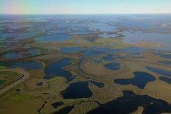
While HALO flies at altitudes of around seven to ten kilometers for remote sensing, in-situ comparative measurements require flights that are as low as possible and therefore as challenging as possible. "For CoMet 2.0 Arctic, for example, we completed extensive low-level passages over the Mackenzie River Delta and also over regions with oil and gas production at 500 to 600 meters above ground," reports DLR research pilot Dr. Marc Puskeiler. The vegetation of wetlands such as the Mackenzie River Delta absorbs a particularly large amount of carbon and later releases it again. Such wetlands are therefore among the most important, albeit least understood, sources and sinks in the global CH4 and CO2 budget.

Methane: Greenhouse gas with a powerful effect
CO2 is generally known as the most important greenhouse gas emitted by humans on earth. What is less well known is that methane (CH4) is about 200 times less concentrated in the atmosphere. However, compared to CO2, each molecule of CH4 has 86 times the effect of a greenhouse gas over the first 20 years. Overall, CO2 has accounted for about 65 percent of global warming since the beginning of the industrial revolution, while CH4 has accounted for about 18 percent of all greenhouse gases emitted by humans.

Climate gas emissions from forest fires
Forest fires are particularly harmful to the climate. "Because in addition to the obvious CO2 released by such fires, they can also become a significant source of methane if combustion is not complete," says Dr. Andreas Fix. But measurement flights near fires cannot be planned in advance and can only be targeted at short notice. However, the CoMet 2.0 Arctic team succeeded in flying over a large forest fire on the edge of the Rocky Mountains.
Wide-ranging cooperation in research flights
The Comet 2.0 Arctic mission of the German research partners is part of a wide range of international collaborations. It is part of the AMPAC initiative (Arctic Methane and Permafrost Challenge) of the European (ESA) and American (NASA) aerospace agencies. AMAC aims to document the analysis of Arctic climate gas emissions. As part of this collaboration, HALO, NASA research aircraft, and Canadian helicopters have already completed jointly coordinated research flights, with measurements comparatively supported by high-altitude research balloons, ground, and ship measurements. In total, HALO will fly about 140 hours as part of this mission, which is funded by DLR, MPI-BGC Jena and DFG.


