BIOMASS delivers first radar images
a new look at the earth's green reserves
To the point:
First images from space successfully received with P-band radar
New technology enables detailed forest structure analyses worldwide
Mission contributes to a better understanding of biomass and carbon storage
Initial image data already shows clear differences in vegetation and soil moisture

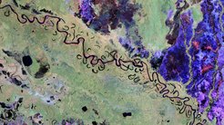
The European Earth observation mission BIOMASS has reached an important milestone: for the first time, radar images have been transmitted from space that were recorded using a new type of sensor in the P-band. This technology makes it possible to visualise the Earth's vegetation structure with unprecedented accuracy. The first images now published provide impressive indications of the mission's potential - both scientifically and technologically.
The P-band radar, which works with a wavelength of around 70 centimetres, penetrates tree crowns and makes deeper layers of vegetation visible. In this way, not only the extent of forest areas can be recorded, but also their structure and biomass. In tropical and boreal regions in particular, which were previously difficult to access or covered by dense forest, this opens up new possibilities for global environmental observation.

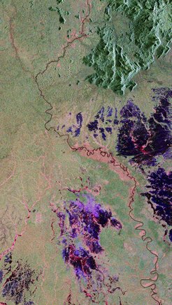
The first images show impressive contrasts between forested areas, wetlands and open terrain. Flood zones, which are characterised by strong backscattering, are particularly clearly visible. Such information is not only important for biomass recording, but also for hydrological analyses and the monitoring of climate impacts.
BIOMASS makes it possible for the first time to create a global map of above-ground biomass - comprehensive, consistent and comparable over long periods of time. This data is crucial for better quantifying natural carbon reservoirs, verifying emissions balances and assessing the effectiveness of international climate protection measures. At the same time, the mission allows changes such as deforestation, degradation or reforestation to be recognised precisely and at an early stage.
The system is currently still in the commissioning phase. In the coming months, the radar instrument will be further calibrated before it goes into regular scientific operation. The available data already confirms the high quality of the sensor and the feasibility of the scientific objectives.
With the first images, BIOMASS has impressively demonstrated that the new technology works - and that it is ready to play a central role in earth observation in the coming years. The mission is already regarded as a milestone in the understanding of global carbon cycles and the role of vegetation in the Earth's climate system.
This content was provided by DLR.
A dedicated BIOMASS project office is run at MPI-BGC to coordinate the scientific use of BIOMASS.
