Measuring carbon dioxide with drones – new prospects for climate research

During the „ScaleX“ measurement campaign, which took place last June and July under coordination by IMK-IFU (Garmisch-Partenkirchen, Germany), an international team of about 60 researchers, technicians, and students investigated a grassland in Peißenberg-Fendt. The deployed measurement systems included for example soil chambers, sensor-equipped unmanned aerial vehicles and remote sensing systems using sound and radio waves as well as lasers. Many different parameters were recorded simultaneously to provide answers to the challenging questions: How well do different measurements of gas exchange between ecosystem and atmosphere match? Do meteorological influences account for the discrepancies? How does the complex terrain with elevations up to 150 m within a radius of 2 km affect the exchange fluxes?
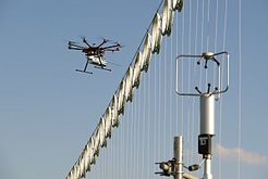
Dr. Jost V. Lavric and Martin Kunz of the Max Planck Institute for Biogeochemistry in Jena (Germany) participated in the ScaleX campaign with ‘COCAP’, a carbon dioxide analyzer weighing only 1 kg that they specifically developed for unmanned aerial vehicles. In cooperation with Prof. Dr. Richard Grant and Evan Flatt of Purdue University (West Lafayette, USA), COCAP was mounted on an octocopter to analyze the spatiotemporal atmospheric carbon dioxide distribution. Combining these measurements with meteorological data enables the scientists to calculate the night-time carbon dioxide emissions of soil and vegetation.
Unmanned aerial vehicles equipped with lightweight and precise measurement devices for greenhouse gases have the potential to become an important tool for the investigation of climate-relevant interactions between biosphere, geosphere, and atmosphere. The data obtained during ScaleX will help pushing forward this approach and validating it with independent methods.


